Chuvashiya, officially the Chuvash Republic, is a federal subject of Russia located in the East European Plain, roughly 650 kilometers (400 miles) east of Moscow. Its map reveals a relatively compact and rectangular territory, spanning approximately 18,300 square kilometers (7,100 sq mi), making it one of the smaller republics within Russia. The Volga River, a dominant geographical feature, bisects Chuvashiya horizontally, splitting the republic into two distinct regions: the upland right bank and the lowland left bank. The Volga is not just a dividing line, but also a vital transportation artery and a source of hydroelectric power, influencing the republic’s economy and infrastructure. Several important ports and industrial centers are situated along its banks. North of the Volga, the terrain is characterized by rolling hills and forests, typical of the Mari Depression. This area features a network of smaller rivers and streams that eventually drain into the Volga. The presence of these waterways and the fertile land have historically supported agriculture and forestry as important sectors in this northern part of the republic. South of the Volga, the landscape shifts to a flatter, more open steppe environment. This region is more intensively cultivated, with large-scale farming operations relying on irrigation where necessary. Here, the land is highly productive for grain crops and other agricultural products. The smaller rivers and streams here also eventually feed into the Volga. The republic is landlocked, bordering the Mari El Republic to the north, the Republic of Tatarstan to the east, the Ulyanovsk Oblast to the south, and the Nizhny Novgorod Oblast to the west. These borders are largely defined by natural features like rivers and watersheds, although some sections are demarcated by administrative lines. The proximity to these regions has fostered cultural and economic exchanges. Cheboksary, the capital city, is prominently located on the right bank of the Volga, acting as the republic’s administrative, industrial, and cultural hub. It’s a major transportation node, connecting Chuvashiya with other regions via river, road, and rail. Other significant cities, such as Novocheboksarsk (located near Cheboksary), and Kanash (a major railway junction), also feature prominently on the map, reflecting their economic importance. The road network within Chuvashiya is relatively well-developed, facilitating the movement of goods and people throughout the republic. Major highways connect Cheboksary with neighboring regions and other major Russian cities. The railway system also plays a crucial role, particularly in transporting industrial goods and raw materials. The map of Chuvashiya also reveals numerous smaller settlements and villages, often clustered around agricultural areas or along waterways. These rural communities play a vital role in preserving Chuvash culture and traditions. Forests cover a significant portion of the republic, particularly in the northern regions, contributing to the biodiversity and environmental health of the area.
 1238×1600 detailed map chuvashia republic russia stock illustration shutterstock from www.shutterstock.com
 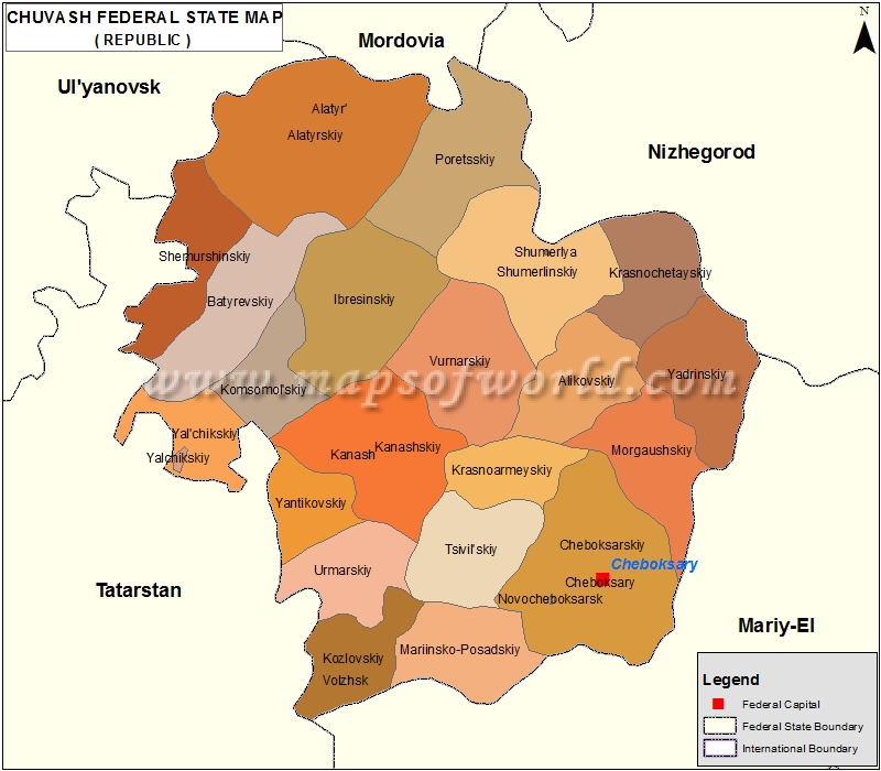 800×700 chuvash republic map chuvash russia map from www.mapsofworld.com
  780×462 chuvash republic chuvashia from www.russianlessons.net
  215×280 detailed map chuvashia republic russia stock vector royalty shutterstock from www.shutterstock.com
  1300×1073 outline map chuvashia flag regions res stock photography images alamy from www.alamy.com
  250×314 chuvashia republic russia guide from russiatrek.org
  1300×1084 chuvash republic russia high resolution satellite map locations names major cities from www.alamy.com
  1300×1387 high quality map chuvashia region russia borders districts stock vector from www.alamy.com
  700×938 filechuvashiapng wikimedia commons from commons.wikimedia.org
  1292×1600 map chuvashia republic russia royalty stock photo avopixcom from avopix.com
  1300×1084 chuvash republic russia open street map locations names major cities region from www.alamy.com
  517×620 map chuvashia republic russia stock vector royalty shutterstock from www.shutterstock.com
  850×778 silver style simple map chuvash republic from www.maphill.com
  518×600 map republic chuvashia amazing tatarstan from tatarstan.eu
  1300×1065 chuvash republic russia colored elevation map lakes rivers stock photo alamy from www.alamy.com
  1055×1390 chuvashia repubic map res stock photography images alamy from www.alamy.com
  540×610 pin chuvashia folklore from www.pinterest.com
  1286×1600 map chuvash republic russia stock vector royalty from www.shutterstock.com
  2560×1920 chuvash state university rector aleksandrov andrey yurievich powerpoint from www.slideserve.com
  626×417 premium photo republic khakassia map chuvashia flag colors editable vector from www.freepik.com
  1000×1080 map republic chuvashia royalty vector image from www.vectorstock.com
  1300×1084 chuvash republic russia colored elevation map lakes rivers locations names from www.alamy.com
  1300×1084 chuvash republic russia grayscale elevation map lakes rivers corner auxiliary from www.alamy.com
  1300×1065 chuvash republic russia high resolution satellite map stock photo alamy from www.alamy.com
  514×569 map chuvash republic chuvashia maps russia regions planetologcom from planetolog.com
  1000×1100 nationalityethnicity map chuvashia maps web from mapsontheweb.zoom-maps.com
  224×280 chuvashia republic russia images stock vectors shutterstock from www.shutterstock.com
  400×280 chuvashia map royalty images stock pictures shutterstock from www.shutterstock.com
  1300×1362 shape chuvash republic russia capital isolated white background colored from www.alamy.com
  850×691 map soil geoecological zoning chuvash republic territory scientific diagram from www.researchgate.net
  1300×1084 chuvash republic russia resolution satellite map locations names major cities from www.alamy.com
  1300×1084 chuvash republic russia elevation map colored wiki style lakes rivers from www.alamy.com