The Amur Oblast, a region in the Russian Far East, sprawls across a vast and geographically diverse territory. A map of this oblast reveals a land dominated by rivers, mountains, and extensive forests, painting a picture of a frontier region rich in natural resources and sparsely populated.
The primary feature dominating the map is the Amur River itself, the namesake of the oblast. It forms the southern border with China, a long and winding boundary crucial for trade and geopolitical considerations. Its tributaries, such as the Zeya and Bureya rivers, carve their way through the landscape, creating fertile valleys and providing vital transportation routes. The map clearly shows the extensive network of waterways that have historically been essential for life and commerce in the region.
The terrain is predominantly mountainous, with the Stanovoy Range stretching across the northern part of the oblast. This range acts as a significant watershed, separating the Arctic Ocean basin from the Amur River basin. To the south, the Tukuringra, Soktakhan, and Dzhagdy mountain ranges contribute to the rugged landscape. These mountain ranges are visible on the map as areas of higher elevation, characterized by dense forests and limited accessibility.
The Zeya-Bureya Plain, located in the central part of the oblast, represents a significant area of relatively flat land. This plain is crucial for agriculture, supporting the region’s limited farming activities. The map highlights the towns and settlements concentrated within this area, reflecting its importance for human habitation.
The map also illustrates the distribution of natural resources. Mining operations, particularly for gold, are prominent features, often indicated by symbols denoting extraction sites and related infrastructure. The vast forests, covering a significant portion of the oblast, are also visually represented, highlighting the importance of the timber industry. The map may also indicate areas rich in other resources, such as coal and various minerals.
Infrastructure is limited across the Amur Oblast, a fact starkly visible on the map. The Trans-Siberian Railway traverses the southern part of the oblast, representing a critical transportation artery. However, outside of this corridor, roads are often unpaved and challenging to navigate, especially during the harsh winter months. The limited road network emphasizes the logistical challenges faced by the region’s inhabitants and industries. Airports, though present, are strategically located to serve the more remote areas.
Finally, a map of the Amur Oblast underscores its isolation and the challenges of developing a region with such a vast territory, rugged terrain, and limited infrastructure. It is a land of immense natural beauty and resources, but also one that requires careful planning and investment to unlock its full potential.
 584×570 map amur oblast maps russia regions planetologcom from planetolog.com
 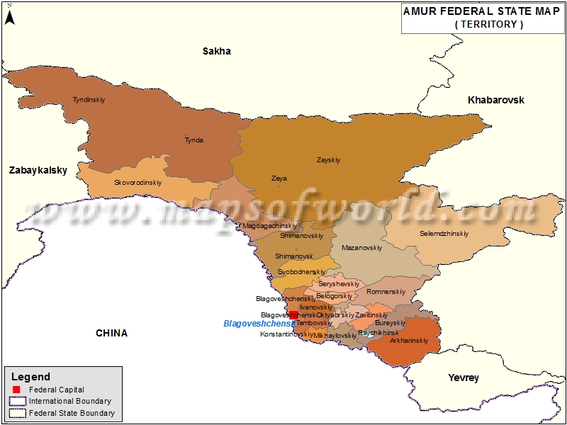 800×600 amur map oblast amur from www.mapsofworld.com
  204×286 amur oblast russia guide from russiatrek.org
  780×398 amur oblast from www.russianlessons.net
  1426×1385 districts amur oblast from snipview.com
  850×678 political map amur oblast images from www.tpsearchtool.com
  1300×1286 outline map amur oblast flag regions russia vector illustration stock photo alamy from www.alamy.com
  423×387 amur region from ar.inspiredpencil.com
  612×606 amur oblast map administrative divisions russia stock illustration image from www.istockphoto.com
  2000×1000 premium vector amur oblast map administrative division russia vector illustration from www.freepik.com
  736×868 map amur oblast from www.pinterest.com
  728×425 amur oblast administrative region russia map amur oblast ru amur oblast from www.worldatlas.com
  850×657 silver style simple map amur oblast from www.maphill.com
  1300×967 amur oblast political map stock vector image art alamy from www.alamy.com
  637×600 karta amurskoi oblasti vysotami skacat kartu from rosmaps.ru
  980×980 amur oblast map administrative division russia illustration vector art vecteezy from www.vecteezy.com
  850×678 physical map amur oblast from www.maphill.com
  1000×1079 map oblast amur royalty vector image from www.vectorstock.com
  1600×1690 amur oblast political map stock vector illustration oblast from www.dreamstime.com
 .svg/256px-Map_of_Russia_-_Amur_Oblast_(2008-03).svg.png) 256×148 amur oblast wikipedia from sv.wikipedia.org
256×148 amur oblast wikipedia from sv.wikipedia.org  1024×940 dateioutline map amur oblastsvg physik schule from www.cosmos-indirekt.de
  1300×1390 high quality map amur oblast region russia borders districts stock vector from www.alamy.com
  368×280 amur oblastrussia map shaded relief map stock illustration from www.shutterstock.com
  1551×1159 level eastern federal district russian geography ultim memrise from www.memrise.com
  120×73 categorymaps amur oblast wikimedia commons from commons.wikimedia.org
  800×720 amur oblast map russia oblast map illustration stock illustration illustration region from www.dreamstime.com