The Ardnamurchan peninsula, a remote and rugged landmass jutting westward from the Scottish Highlands, demands a map. Navigating its intricate tapestry of lochs, glens, and rocky coastline without one is a fool’s errand. Fortunately, readily available Ordnance Survey maps (specifically Landranger 40 and Explorer 391 & 392) provide the essential cartographic detail for exploration.
The most striking feature revealed by any Ardnamurchan map is its dramatic coastline. A deeply indented edge, carved by glacial action and relentless sea erosion, creates a labyrinth of inlets, bays, and sea lochs. Look closely and you’ll see Loch Sunart, a long, slender sea loch separating Ardnamurchan from Morvern to the south. To the north lies Loch Moidart, its own complex network of waterways providing shelter and beauty.
Inland, the map depicts a landscape dominated by mountainous terrain. Ben Hiant, the peninsula’s highest peak, stands prominently, its contour lines a testament to its steep, challenging slopes. The surrounding glens, carved by rivers and glaciers, offer more accessible routes, though even these can be demanding. Pay attention to the map’s depiction of elevation – Ardnamurchan is not a place for flatlanders! Boggy ground is also common, indicated by marsh symbols, a reminder to wear appropriate footwear and heed warnings.
Roads on the Ardnamurchan map are a study in perseverance. Single-track roads, often winding and narrow, are the norm. Passing places, indicated by ‘PP’ symbols, are crucial for avoiding frustrating standoffs. The main route, the A861, skirts the southern edge of the peninsula, offering stunning views but requiring careful driving. Be aware that some roads may be unsuitable for low-slung vehicles. Check for seasonal road closures, particularly after heavy snow.
Scattered across the map are settlements, marked by clusters of buildings. Kilchoan, the peninsula’s largest village, boasts a ferry terminal providing access to Tobermory on the Isle of Mull. Sanna, with its pristine beaches and dramatic dunes, is another point of interest. Small hamlets like Acharacle and Salen offer glimpses into rural life, often clustered around the heads of lochs. Pay close attention to the location of amenities, such as shops, pubs, and petrol stations – they are few and far between.
Finally, the map reveals the stark beauty of Ardnamurchan’s wild, untouched landscape. Expansive areas of moorland, indicated by heather symbols, stretch across the interior. Forested areas, both natural and planted, provide pockets of shelter and habitat. This is a land where the map is not just a navigational tool, but a key to understanding the unique character of this remote and captivating corner of Scotland.
 1268×852 ardnamurchan peninsula map peninsula scotland from www.pinterest.com
 -22877-p.jpg?v=EDB5943F-30DB-4686-9C1F-C70C54F1BCA1) 1586×860 ardnamurchan ordnance survey wall map map centre press from www.themapcentre.com
1586×860 ardnamurchan ordnance survey wall map map centre press from www.themapcentre.com  500×500 os map ardnamurchan explorer map ordnance survey shop from shop.ordnancesurvey.co.uk
  453×292 ardnamurchan peninsula map from www.pinterest.co.uk
  1725×848 catering ardnamurchan catering cottages ardnamurchan peninsula west from www.west-scotland-tourism.com
  743×628 click scotland map detailed map ardnamurchan peninsula from www.sannabay.co.uk
  1631×1365 ardnamurchan loop road trip natures grid treasures scotland highlands travel road from www.pinterest.com
  1410×1109 tangent ardnamurchan lighthouse from off-at-a-tangent.blogspot.com
  430×270 ardnamurchan visiting maps from visitingallthemaps.wordpress.com
  873×681 fenfolio ardnamurchan treshnish isles from fenfolio.blogspot.com
  1024×655 place heritage ardnamurchan from heritageardnamurchan.co.uk
  300×297 ardnamurchan clan maciain ardnamurchan from www.clanmaciain.com
  1800×1144 ardnamurchan map from www.british-coast-maps.com
  2360×795 ardnamurchan loop road trip natures grid treasures from naturesoffgridtreasures.com
  0 x 0 ardnamurchan viking boat burial discovery bbc news from www.bbc.co.uk
 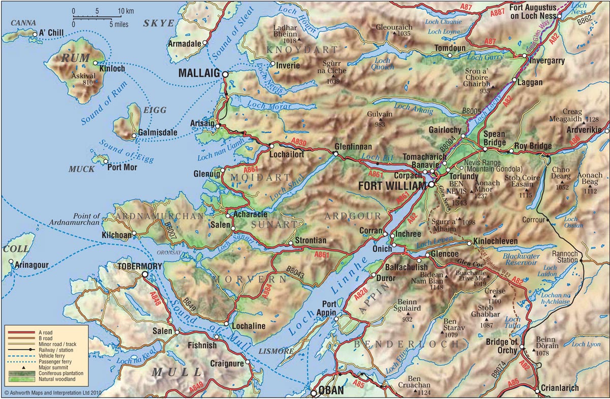 1200×786 schottland ardnamurchan from ottoschaefer.de
  1199×582 geologic map ardnamurchan peninsula square mile km peninsula ward from www.pinterest.com
  1002×653 ardnamurchan trout fishing scotland from www.trout-salmon-fishing.com
  1073×669 ardnamurchan hikes food beautiful beaches from www.twoscotsabroad.com
  840×479 ardnamurchan western jewel scotland whisky wisdom from www.whiskyandwisdom.com
  850×465 map scotland showing ardnamurchan peninsula generalized scientific diagram from www.researchgate.net
  247×298 localisation ardnamurchan scotland map scientific diagram from www.researchgate.net
  850×1023 simplified geological map ardnamurchan peninsula based scientific diagram from www.researchgate.net
  320×320 simplified geological map ardnamurchan central complex scientific diagram from www.researchgate.net