The Black Mountains, known as Y Mynyddoedd Duon in Welsh, form the eastern part of the Brecon Beacons National Park in Wales. Understanding the terrain through a good map is crucial for anyone exploring this stunning landscape, whether for hiking, mountain biking, or simply enjoying the scenery.
Ordnance Survey (OS) maps are the gold standard for navigating the Black Mountains. The OS Explorer series (1:25,000 scale) provides the greatest detail, showing individual fields, paths, streams, and even walls, making them ideal for off-trail walking. OS Landranger maps (1:50,000 scale) offer a broader overview, suitable for planning routes and understanding the overall topography.
Key areas covered by maps of the Black Mountains include:
- Waun Fach: The highest point in the Black Mountains, marked prominently. Navigating to and from Waun Fach requires careful attention to contour lines, as the summit is a broad, relatively flat plateau.
- Hay Bluff: Easily recognizable with its distinctive cliffs overlooking Hay-on-Wye. OS maps will highlight the popular paths leading to the summit and the more challenging scrambles.
- Pen y Fan (though technically Brecon Beacons): Maps often include the fringes of the central Brecon Beacons, allowing for routes that combine both mountain ranges.
- River valleys: The Usk, Honddu, and Monnow valleys define the Black Mountains’ borders. Maps are essential for identifying fords, bridges, and potentially flooded areas, especially after heavy rain.
- Towns and Villages: Hay-on-Wye, Llanthony, Crickhowell, and Abergavenny are key access points. Maps highlight amenities, parking, and public transport links within these settlements.
Beyond physical maps, digital mapping apps like OS Maps, ViewRanger (now merged with OS Maps), and Komoot are invaluable. These apps utilize GPS, allowing you to pinpoint your location on the map in real-time. They often provide pre-planned routes, elevation profiles, and the ability to download maps for offline use – essential in areas with limited mobile signal.
When reading a map of the Black Mountains, pay close attention to contour lines. Closely spaced lines indicate steep slopes, while widely spaced lines suggest gentler gradients. Identifying key features like streams, forests, and rock outcrops will aid navigation. The direction of streams will show which way water is flowing and hence which way is downhill. Grid references (e.g., SO 240 300) allow you to accurately pinpoint locations. The map key explains the symbols used, from different types of paths to various land uses.
Weather in the Black Mountains can change rapidly. Even on a clear day, carrying a waterproof map and compass, and knowing how to use them, is crucial. Relying solely on electronic devices is risky, as battery life can be unpredictable. Combining traditional map reading skills with modern technology is the safest and most rewarding approach to exploring the Black Mountains.
 600×824 map black mountains wales from www.w2n.net
  1428×791 black mountains wales map celene annamarie from sherilloaggie.pages.dev
  1024×646 black mountain from www.cavinguk.co.uk
  677×677 ordnance survey landranger map black mountains countryside ski climb from www.countryside.co.uk
 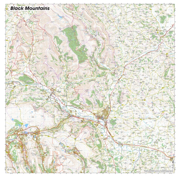 594×587 black mountains splashmapssplashmaps from www.splash-maps.com
  1600×1131 peak bagging long distance walking uk spain black mountains south from stevejsmith56englishnuttalls.blogspot.com
  1024×718 black mountains land partnership black mountains land partnership from www.blackmountains.wales
  1024×1024 black mountains area access map diagrams topos summitpost from www.summitpost.org
  1300×956 black mountains map res stock photography images alamy from www.alamy.com
 .jpg) 1131×1600 peak bagging long distance walking uk spain july black mountains from stevejsmith56englishnuttalls.blogspot.com
1131×1600 peak bagging long distance walking uk spain july black mountains from stevejsmith56englishnuttalls.blogspot.com  826×716 black mountains from www.splash-maps.com
  750×600 black mountain pass motogoloco classics mountain pass black mountain classic from www.pinterest.co.uk
  748×494 abrs weekend ride beautiful black mountain pass adventure bike rider from www.adventurebikerider.com
 .jpg) 1131×1600 peak bagging long distance walking uk spain black mountains north from stevejsmith56englishnuttalls.blogspot.com
1131×1600 peak bagging long distance walking uk spain black mountains north from stevejsmith56englishnuttalls.blogspot.com  1024×765 black mountains map wales mapcarta from mapcarta.com
  711×750 black mountains wye valley walking explore days abergavenny abergavenny from www.globaljourneys.com
  600×312 black mountains panorama map burnsville north carolina mappery from www.mappery.com
  486×450 revised series black mountains cassini maps shopping cart from www.cassinimaps.co.uk
  400×332 satellite map black mountain from www.maphill.com
  2558×1389 black mountain panorama map balck mountain nc mappery from www.mappery.com
  700×623 black mountains popular edition sheet map from www.francisfrith.com
  630×315 welsh mountains list magnificent mountains wales from www.twinkl.co.cr
  1200×616 black mountain trail map skicentralcom from www.skicentral.com