Brighton, a vibrant seaside city in East Sussex, England, boasts a captivating map reflecting its rich history and modern evolution. Its geography is defined by the English Channel to the south and the rolling South Downs to the north, creating a unique landscape that has shaped its development.
The historic heart of Brighton, clustered around the iconic Brighton Pier and the Royal Pavilion, is a labyrinthine network of narrow, winding streets known as “The Lanes.” This area, marked on the map by its dense, irregularly shaped blocks, is a pedestrianized haven filled with independent shops, antique dealers, and artisan workshops. Its intricate layout reflects the organic growth of the town from its humble fishing village origins.
Moving east from the Pier, the map reveals a gradual transition to the broader avenues and Regency architecture of Kemp Town. This area, known for its colourful buildings and LGBTQ+ community, features a more grid-like street pattern, a testament to the planned expansion of Brighton during the Regency era. The expansive green space of Queen’s Park marks the eastern edge of Kemp Town, providing a contrast to the urban density.
To the west of the city centre lies Hove, often considered Brighton’s more refined neighbour. The map shows Hove characterized by its wide, tree-lined boulevards, grand Regency squares like Brunswick Square and Adelaide Crescent, and elegant seafront properties. The Hove Lawns, a long strip of green separating the promenade from the residential area, is a prominent feature on the map, highlighting the area’s emphasis on open space and leisure.
Northward, the map illustrates the encroachment of suburban development towards the South Downs National Park. Areas like Patcham and Hollingbury feature a mix of residential estates, green spaces, and arterial roads connecting Brighton to the surrounding region. The presence of the A27 bypass is clearly visible, a significant transportation artery that skirts the northern edge of the city.
Brighton’s seafront, prominently displayed on any map, is a continuous stretch of pebble beach punctuated by notable landmarks. The i360 observation tower stands as a modern addition, while the Victorian arches lining the promenade offer shelter and host various businesses. The marina, located to the east of the city, is a significant feature, showcasing Brighton’s connection to the sea and offering recreational boating facilities.
Overall, the map of Brighton reflects a city that has gracefully blended its historical roots with modern aspirations. From the intricate lanes of the old town to the elegant squares of Hove and the natural beauty of the South Downs, Brighton’s geography and urban planning create a diverse and captivating landscape that continues to attract visitors and residents alike.
 1800×1097 brighton map from www.oldemaps.co.uk
  450×338 brighton maps orientation brighton east sussex england from www.world-guides.com
  1588×1430 illustrated map brighton east sussex brighton art print etsy from www.etsy.com
  625×385 map east sussex from www.1066online.com
  1290×1690 map city brighton east sussex south east england england uk stock illustration from www.dreamstime.com
  2776×2450 large brighton maps print high resolution detailed maps from www.orangesmile.com
  1000×780 modern map east sussex county brighton districts labels uk east sussex modern from br.pinterest.com
  800×495 map brighton stock illustrations map brighton stock illustrations vectors clipart from www.dreamstime.com
  1024×1024 brighton hove east sussex uk city street map stock illustration image map from www.istockphoto.com
  363×250 modern map east sussex county brighton vector image from www.vectorstock.com
  474×291 east sussex area map from www.1066online.com
  595×595 east sussex county boundaries map from www.gbmaps.com
  1024×638 east sussex county map love maps from www.ilovemaps.co.uk
 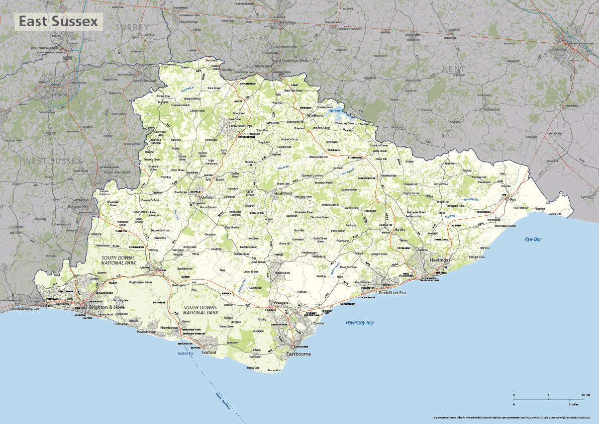 1192×843 east sussex county map maproom from maproom.net
  1300×798 brighton antique town city plan res stock photography images alamy from www.alamy.com
  1600×970 map city brighton hove east sussex south east england england uk stock from www.dreamstime.com
  700×528 top tourist attractions brighton east sussex planetware from www.planetware.com
  999×623 maps brighton sussex francis frith from www.francisfrith.com
 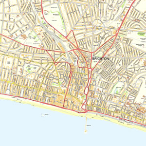 300×300 sussex offline map including eastbourne brighton bognor regis beachy head chichester battle from www.mapmoose.com
  909×738 east sussex joint strategic assessment from www.eastsussexjsna.org.uk
  1000×756 brighton hove map brighton customised show specific points interest merritt from merrittcartographic.co.uk
  474×382 map east sussex england uk map uk atlas eastbourne england map england east sussex from www.pinterest.co.uk
  3935×2416 suggests visit patcham fabulous tourist map brighton hove brighton from www.pinterest.com
  400×300 victorian colour map brighton ordnance survey east sussex coast ebay uk from www.ebay.co.uk
  400×496 brighton hove brighton hove map from www.getthedata.com
  1280×698 antique maps brighton sussex from www.rareoldprints.com
  235×165 maps brighton hove ideas brighton brighton hove hove from www.pinterest.com
  480×313 brighton wikipedia from en.wikipedia.org
  500×326 brighton wikipedia from en.wikipedia.org