Navigating Chamonix-Mont-Blanc’s bustling town center is best achieved with a reliable map. Such a map reveals a pedestrian-friendly layout, radiating outwards from the central Place Balmat, a square named after one of the first men to summit Mont Blanc. Place Balmat serves as a natural starting point, easily identifiable by its fountain and the statue of Balmat pointing towards the majestic peak.
The map will clearly delineate the main artery, Avenue Michel Croz, packed with outdoor gear shops, souvenir stores, and cafes. This avenue runs roughly parallel to the Arve River, a fast-flowing waterway that bisects the town. Keep an eye out for bridges marked on the map, providing crucial access across the river to quieter residential areas and alternative routes.
Side streets branching off Avenue Michel Croz are often pedestrianized and filled with hidden gems. The Rue du Docteur Paccard, for instance, is known for its boutiques and restaurants. The map will highlight these pedestrian zones, indicated by a different shading or dotted lines, emphasizing their accessibility and charm.
Pay close attention to the locations of key landmarks marked on the map. The Tourist Office is a vital resource for information and is prominently displayed. The church, Eglise Saint-Michel, with its distinctive spire, acts as another useful orientation point. Other important locations include the train station (Gare de Chamonix-Mont-Blanc), the Maison de la Montagne (Mountain House), and the cinema.
The map should also indicate the positions of bus stops and taxi stands, crucial for accessing areas outside the immediate town center or for reaching the various lift stations leading up the mountains. Cable car departure points, such as the Aiguille du Midi and Brévent, are usually marked on the outskirts of the central area and easily accessible via a short walk or bus ride.
Restaurants, hotels, and public restrooms are also typically indicated with specific symbols. Larger hotels often occupy prominent positions along the main avenues, while smaller, more traditional establishments are tucked away on side streets. Detailed maps may also include points of interest such as art galleries, museums (like the Alpine Museum), and notable architectural features.
Finally, a good map of Chamonix center will clearly show the direction of north, enabling you to orient yourself effectively. Understanding the relative positions of Mont Blanc and the other surrounding peaks provides an immersive sense of location, turning a simple map into a portal to the alpine environment that defines Chamonix’s unique character.
 2236×1568 chamonix town map ontheworldmapcom from ontheworldmap.com
 600×451 chamonix town map from ar.inspiredpencil.com
 800×579 shopping chamonix from www.highmountain.co.uk
 1741×1191 tourist map chamonix from mavink.com
 1000×759 chamonix from hiske.leif.perso.ch
 804×658 chamonix town map town map tourist map chamonix from www.pinterest.com
 275×185 chamonix town maps les houches town argentiere village map from www.chamonix.net
 910×600 stadtplan von chamonix from ger.animalia-life.club
 1530×1034 chamonix printable tourist map tripomatic from tripomatic.com
 742×616 large detailed map chamonix from ontheworldmap.com
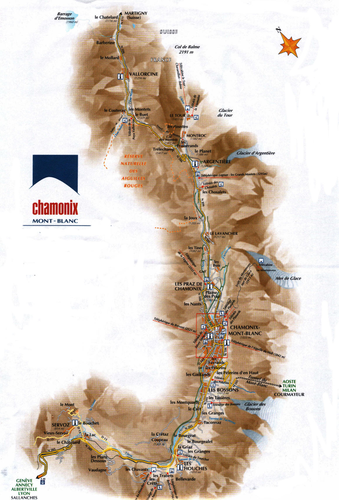 1160×1709 chamonix town maps travel advice chamonix from www.chamonix.net
 2480×1653 chamonix ski map from ontheworldmap.com
 600×371 chamonix ski resort guide location map chamonix ski holiday accommodation from www.snow-forecast.com
 640×427 chamonix map from mungfali.com