Mapping the Queen City: Navigating Charlotte, NC
Charlotte, North Carolina, affectionately known as the Queen City, is a vibrant and rapidly growing metropolis. Understanding its map is crucial for both residents and visitors alike. The city’s layout, a blend of traditional grid systems and modern suburban sprawl, can initially seem complex, but with a basic grasp of key areas and landmarks, navigating Charlotte becomes significantly easier.
At Charlotte’s heart lies Uptown, the central business district. Think of it as a smaller, cleaner, and more manageable version of a typical big-city downtown. Uptown is organized around four main wards: First Ward, Second Ward, Third Ward, and Fourth Ward. These wards radiate outwards from the intersection of Trade and Tryon Streets, marked by the iconic statue of Queen Charlotte, the city’s namesake. Uptown is home to major corporations, sports venues like Bank of America Stadium (home of the Carolina Panthers) and Spectrum Center (home of the Charlotte Hornets), cultural institutions like the Blumenthal Performing Arts Center, and numerous restaurants and bars.
Surrounding Uptown are distinct neighborhoods each with its own character. South End, directly south of Uptown, is known for its trendy breweries, art galleries, repurposed industrial spaces, and vibrant nightlife. It’s easily accessible via the LYNX Blue Line, a light rail system that runs north-south. NoDa (North Davidson), to the northeast of Uptown, is Charlotte’s arts district, brimming with colorful murals, eclectic shops, and live music venues. It’s a haven for artists and creatives.
Further out, you’ll find neighborhoods like Dilworth, a historic area with tree-lined streets, charming bungalows, and popular restaurants. Myers Park is an affluent residential area known for its stately homes and manicured lawns. Plaza Midwood is a diverse and hip neighborhood with a mix of vintage shops, independent boutiques, and diverse dining options.
The city’s major highways, I-77 (north-south) and I-85 (northeast-southwest), intersect near Uptown, providing access to other parts of North Carolina and beyond. The outer loop, I-485, circles the city, connecting the various suburbs and facilitating travel around Charlotte. Using GPS navigation or online mapping tools is highly recommended, especially when navigating the complex interchanges and traffic patterns.
Beyond the central core, Charlotte sprawls outwards into numerous suburban communities, each with its own shopping centers, schools, and recreational facilities. Areas like Ballantyne, SouthPark, and University City offer a mix of residential and commercial developments. Lake Norman, a large man-made lake north of Charlotte, is a popular destination for boating, fishing, and other water activities.
Understanding Charlotte’s map involves recognizing the importance of Uptown as its central hub and appreciating the unique character of its surrounding neighborhoods. Utilizing available transportation options, including the LYNX Blue Line and ride-sharing services, can greatly simplify navigation. With a little exploration and a willingness to discover, Charlotte’s diverse landscape offers something for everyone.
 1805×1340 charlotte douglas international airport clt terminal guide from upgradedpoints.com
  1920×1440 terminals map charlotte douglas airport clt north carolina from airport-clt.com
 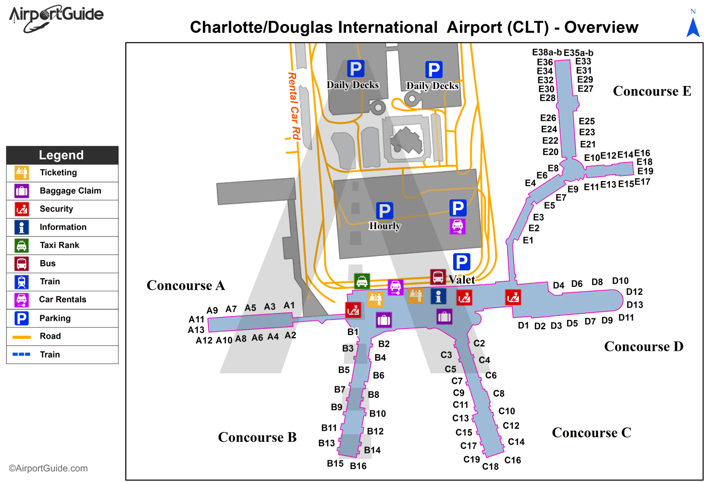 1400×958 charlotte charlottedouglas international clt airport terminal maps travelwidgetcom from travelwidget.com
  1280×865 terminals charlotte douglas international airport clt map from airport-in-charlotte.com
  560×435 charlotte douglas airport map clt terminal guide from www.ifly.com
  708×629 charlotte douglas airportclt terminal maps shops restaurants food court from www.tripindicator.com
  990×925 behance from www.behance.net
  1178×1690 map charlotte douglas international airport iata code clt stock photo image from www.dreamstime.com
  1400×958 charlotte charlottedouglas international clt airport terminal map overview airport guide from www.pinterest.ph
  600×1100 charlotte airport clt terminal map from www.travelnerd.com
  2000×2000 charlotte douglas airport map terminals parking airportmapscom from www.airportmaps.com
  1077×841 clt airport diagram airport charlotte clt carolina north from diagramsacristaincc0.z21.web.core.windows.net
 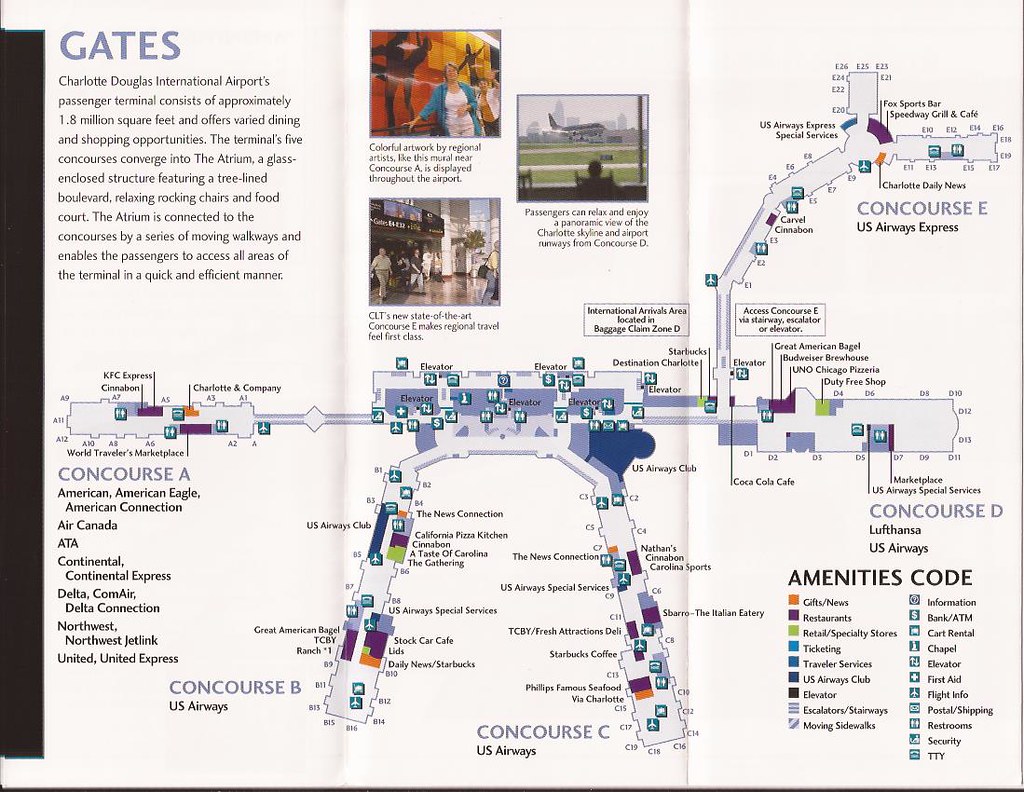 1024×792 charlotte douglas international airport clt terminal map flickr from www.flickr.com
  581×435 aa guide clt charlotte douglas airport mct connection flyertalk forums from www.flyertalk.com
  1500×2000 charlotte douglas international airport ea clt ea from www.airportprojects.net
 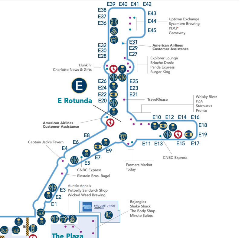 800×785 charlotte airport map navigate clt airport ease czsm from czsmartmobility.com
  390×290 clt concourse map from mavink.com
  1000×1294 clt airport parking rates charlotte douglas international from airportparking.tips
  2048×2048 navigating global network comprehensive guide charlotte douglas international from usamaphd.pages.dev
  494×300 charlotte nc clt from www.aa.com
  828×828 charlotte airport map guide clts terminals from www.ifly.com
  1000×1482 terminals clt airport rafael gilliam blog from storage.googleapis.com
  474×255 parking map charlotte douglas international airport clt from airport-clt.com
  1200×630 charlotte douglas airport clt terminal maps airport guide from www.airport.guide