Exploring the Costa Almeria: A Geographical Overview
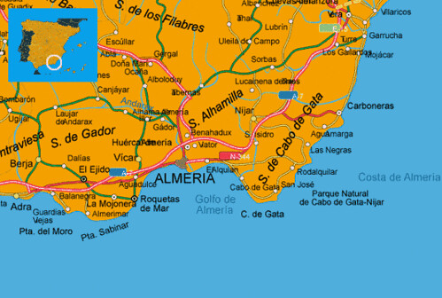
The Costa Almeria, located in the southeastern corner of Spain, boasts a diverse landscape and a rich history, all readily apparent when examining a map of the region. Understanding its geography is key to appreciating its appeal.
The coastline itself stretches for approximately 200 kilometers along the Mediterranean Sea. Its map reveals a captivating blend of dramatic cliffs, long sandy beaches, and hidden coves. To the east, near the border with the Murcia region, the landscape tends to be flatter, with expansive beaches like Vera Playa and Garrucha. These areas are popular for their family-friendly resorts and watersports.
Moving westward, the terrain becomes more rugged, particularly as you approach the Cabo de Gata-Níjar Natural Park. The park, clearly delineated on the map, is a UNESCO Biosphere Reserve, characterized by volcanic rock formations, secluded beaches, and crystal-clear waters. Its coastline is a labyrinth of calas (coves), each offering unique beauty and tranquility. Locations like Monsul beach and Genoveses beach, within the park boundaries, are easily identifiable on a detailed map and known for their dramatic scenery.
Inland, the map showcases the dramatic contrast between the coastal strip and the mountainous interior. The Sierra Nevada mountain range, though not directly on the Costa Almeria, influences the climate and provides a stunning backdrop visible from many coastal points. The presence of smaller mountain ranges, such as the Sierra Alhamilla, is also noticeable and contributes to the varied microclimates within the region.
The map highlights the presence of several key towns and cities. Almeria city, the provincial capital, sits strategically on the coast with a large port and access to major transportation routes. Smaller towns like Mojacar, known for its whitewashed architecture perched on a hilltop, and Roquetas de Mar, a bustling tourist center, are also prominent. These towns serve as hubs for exploring the surrounding areas.
Irrigation channels and agricultural areas are also visible on the map, particularly inland where the landscape is relatively flat. The Costa Almeria is known for its greenhouse agriculture, producing a significant portion of Europe’s fruits and vegetables. These areas are often clustered around water sources and are indicative of the region’s agricultural importance.
Finally, a good map of the Costa Almeria will clearly show the road network, which is crucial for navigating the region. The A-7 Mediterranean highway runs along much of the coast, providing easy access to most towns and attractions. Smaller roads and tracks wind through the Cabo de Gata Natural Park, offering more adventurous routes for exploring its hidden corners.
In conclusion, studying a map of the Costa Almeria unveils a region of striking geographical contrasts, from its sun-drenched beaches to its rugged mountains and fertile plains. It’s a landscape that offers something for every traveller, and understanding its geography is the first step in planning an unforgettable visit.
 499×336 maps spain costa almeria map costa dem almeria spanish flickr from www.flickr.com
  1024×640 map costa de almeria from howtobuyinspain.com
  550×440 map costa de almeria region spain welt atlasde from www.welt-atlas.de
  500×477 costa de almeria spain tourist information from www.spain-calling.com
  768×509 costa almeria map spainsavvy from spainsavvy.com
  468×294 costa de almeria travel guide holidays costa de almeria from www.spainted.com
  475×315 word travels travel guide destination guides world traveller cities map from www.wordtravels.com
  1080×1321 almeria top almeria spain travel almeria andalusia spain beach from www.beachtravelwine.com
  490×192 map almeria province andaluciacarcom from www.andaluciacar.com
  1125×1172 large almeria maps print high resolution detailed maps from www.orangesmile.com
  474×246 places visit costa de almeria from howtobuyinspain.com
  581×503 beach holidays south east spain almeria from www.vacation2spain.com
  150×123 guide costa almeria from xyuandbeyond.com
  297×526 almeria province complete map spain from www.malagacar.com
  488×456 almeria holiday rentals villas rent holiday homes from www.holidayhomesdirect.ie
  450×317 maps almeria university almeria universidad de almeria map almeria university spain from www.almeria.university-guides.com
  267×200 costa de almeria spain from www.red2000.com
  600×525 almeria towns map from www.malagacar.com
  323×450 almeria coast map almeria almeria coast map spain from www.malagacar.com
  435×615 es map almeria spain flickr from www.flickr.com
  400×300 costa almeria from key4living.com
  300×300 costa de almeria holidays book costa de almeria hotels holidays sunshine from www.sunshine.co.uk
  460×287 maps city almeria andalucia southern spain from www.andalucia.com
  496×438 costa de almeria stranden strandenspanjecom from strandenspanje.com
  492×222 map almeria from www.alicante-spain.com
  600×572 almeria province map full size gifex from www.gifex.com
  850×840 physical map almeria from www.maphill.com
  741×727 costa de almeria onderweg naar spanje from blog.nicla-casas.com
  618×618 road almeria from afoodieineurope.blogspot.co.uk
  1000×966 almeria map spain province administrative map vector image from www.vectorstock.com