Kirov Oblast, located in the European part of Russia, presents a diverse and fascinating geographical landscape, comprehensively captured on its maps. Understanding the map of Kirov Oblast reveals much about its economic activities, population distribution, and historical development.
At first glance, the map highlights the prominent role of water bodies. The Vyatka River, the region’s main artery, meanders across the oblast, influencing settlements and agricultural practices. Many smaller rivers and lakes, dotting the map, contribute to the rich ecosystem and are important for transportation and local industries like fishing. Notice how population centers often cluster along these waterways.
The map further illustrates the dominance of forests. Kirov Oblast is part of the taiga zone, and vast expanses of coniferous and mixed forests cover the majority of the territory. This explains the significant timber industry, visible through the locations of lumber mills and processing plants indicated on detailed maps. The density of forest coverage impacts road construction and the accessibility of certain areas, contributing to the relatively low population density outside the major cities.
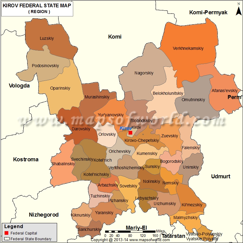
Looking closer, one can identify the major urban centers. Kirov city, the administrative center, is strategically located along the Vyatka River. Other significant towns like Kirovo-Chepetsk, Kotelnich, and Vyatskiye Polyany appear as important nodes linked by road and rail networks. The placement of these towns reflects the historical development of the region, often associated with resource extraction, trade routes, and industrial development.
The road and railway network is another key feature represented on the map. The Trans-Siberian Railway passes through Kirov Oblast, connecting it to other regions of Russia and playing a vital role in the transportation of goods. Major highways link the urban centers and provide access to surrounding areas. However, the map also reveals areas with limited road access, indicating less developed regions, often characterized by smaller villages and reliance on traditional industries.
Finally, specialized maps of Kirov Oblast can provide detailed information on specific aspects. Geological maps showcase the region’s mineral resources, influencing mining activities. Agricultural maps highlight the areas suitable for farming, indicating the main crops cultivated. Tourist maps feature natural attractions, such as national parks, nature reserves, and historical sites, showcasing the oblast’s potential for ecotourism and cultural heritage preservation.
In conclusion, a thorough examination of the map of Kirov Oblast provides valuable insights into its geography, economy, infrastructure, and population distribution. It’s a vital tool for understanding the region’s past, present, and future development.
 800×800 kirov map oblast kirov russia from www.mapsofworld.com
 1000×1079 map oblast kirov royalty vector image vectorstock from www.vectorstock.com
 300×308 kirov oblast russia guide from russiatrek.org
 780×410 kirov oblast from www.russianlessons.net
 1300×1242 outline map kirov oblast flag regions russia vector illustration stock photo alamy from www.alamy.com
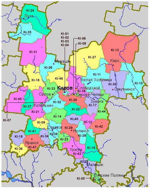 480×600 whkmla history kirov oblast from www.zum.de
 666×774 maps kirov oblast from maps.newsruss.ru
 1199×1390 kirov oblast political map stock vector image art alamy from www.alamy.com
 1300×1390 high quality map kirov oblast region russia borders districts stock from www.alamy.com
 290×358 deutsches lehrmittel und kulturzentrum kirov from vkirove.ru
 1024×1024 kirov oblast map world map international vector template russia region silhouette vector from www.istockphoto.com
.svg/512px-Map_of_Russia_-_Kirov_Oblast_(2008-03).svg.png) 512×295 kirov oblast wikipedia from sv.wikipedia.org
512×295 kirov oblast wikipedia from sv.wikipedia.org 1024×768 kirov region oblast from slideplayer.com
.gif) 580×400 kirov oblast topographic maps mapstorcom from mapstor.com
580×400 kirov oblast topographic maps mapstorcom from mapstor.com 980×980 kirov oblast map administrative division russia illustration vector art vecteezy from www.vecteezy.com
 1600×1674 kirov oblast administration map russia stock illustration illustration flag blue from www.dreamstime.com
 1000×708 vector map russia map kirov county highlighted red stock vektorgrafik adobe stock from stock.adobe.com
 368×280 kirov oblastrussia map shaded relief map stock illustration shutterstock from www.shutterstock.com
 1600×1157 kirov oblast map vector stock vector illustration design from www.dreamstime.com
 750×750 map kirov russia global atlas from www.europa.uk.com
 800×800 kirov location kirov russia map from www.mapsofworld.com
 1600×1674 kirov oblast administration map russia stock illustration illustration symbol flag from www.dreamstime.com
 1440×1440 kirov kirov oblast russia crazy colorful map print template colorful map map print from www.pinterest.com
 96×120 categorysvg maps kirov oblast wikimedia commons from commons.wikimedia.org
 392×320 kirov region russia high resolution satellite map locations major cities region from www.alamy.com
 1300×1377 emblem kirov oblast map administrative divisions borders russia stock photo from www.alamy.com
 1200×1690 flag map kirov oblast stock vector illustration moscow from www.dreamstime.com
 728×425 kirov russia kirov kirov oblast map worldatlascom from www.worldatlas.com
 675×381 map russia indicating geographical positions kirov smolensk scientific from www.researchgate.net
 1600×1674 kirov oblast administration map russia stock illustration illustration region emblem from www.dreamstime.com
 1300×1390 map kirov city russia stock photo alamy from www.alamy.com