The Novgorod Oblast, situated in northwestern Russia, presents a diverse landscape reflected in its map. Characterized by a mix of lowlands, hills, and extensive waterways, the map reveals a region heavily influenced by its natural features.
The dominant feature is Lake Ilmen, a large, shallow lake located in the west-central part of the oblast. Its irregular shape and numerous inlets and islands are clearly visible on the map. Historically significant as part of the “Way from the Varangians to the Greeks” trade route, Lake Ilmen drains into the Volkhov River, a crucial waterway that flows northward. The Volkhov River, also prominent on the map, connects Lake Ilmen to Lake Ladoga, showcasing the integrated water system that has shaped the region’s history and economy.
To the east of Lake Ilmen, the map displays the Valdai Hills, a range of rolling hills that form a portion of the larger Valdai Hills system. While not particularly high, these hills are vital as the source of many rivers, including the Msta, which flows northwest towards Lake Ilmen. This hilly terrain contrasts with the generally flat or gently undulating landscapes that dominate much of the oblast.
The map indicates a network of rivers and streams crisscrossing the territory. These waterways have historically served as transportation routes, providing access to remote areas and facilitating trade. The Msta, Lovat, Pola, and Shelon Rivers are among the most significant, each contributing to the region’s drainage system and ecological diversity.
Looking at the map, one can discern the distribution of population centers. Veliky Novgorod, the administrative center and a historic city, is strategically located on the Volkhov River, near Lake Ilmen. Other towns, such as Borovichi, Valday, and Staraya Russa, are situated along major waterways or near important transportation routes. The road network, clearly marked on the map, connects these urban centers and facilitates movement throughout the oblast.
Forests cover a significant portion of the Novgorod Oblast, indicated by the green areas on the map. These forests, primarily coniferous and mixed, contribute to the region’s timber industry and biodiversity. Agricultural land is concentrated in the areas surrounding Lake Ilmen and along the major rivers, reflecting the fertile soils found in these areas.
The administrative boundaries of the Novgorod Oblast are also clearly defined on the map, showing its relationship to neighboring regions such as the Leningrad, Tver, Pskov, and Vologda Oblasts. Studying the map of Novgorod Oblast provides valuable insights into its geography, history, economy, and the interplay between human activity and the natural environment.
 780×433 novgorod oblast from www.russianlessons.net
 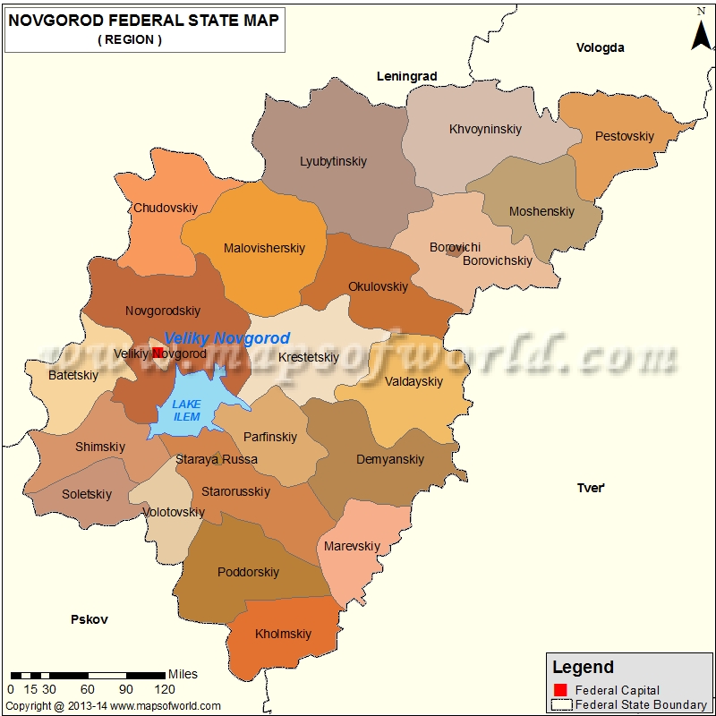 800×800 novgorod map oblast novgorod russia from www.mapsofworld.com
  480×384 whkmla history novgorod oblast from www.zum.de
  1599×1172 filenovgorod oblast mapsvg wikitravel shared from wikitravel.org
  800×1059 map nizhny novgorod oblast from maps.newsruss.ru
  300×241 novgorod oblast russia guide from russiatrek.org
  718×567 novgorod region from tadviser.com
  800×1000 nizhny novgorod map oblast nizhny novgorod russia from www.mapsofworld.com
  1000×868 maps novgorod oblast from maps.newsruss.ru
  1300×1387 map novgorod res stock photography images alamy from www.alamy.com
  850×286 shaded relief panoramic map novgorod oblast from www.maphill.com
  1245×1390 outline map novgorod oblast flag regions russia vector illustration stock photo alamy from www.alamy.com
  1000×1080 map oblast nizhny novgorod royalty vector image from www.vectorstock.com
  501×367 novgorod oblast wikitravel from wikitravel.org
  1300×1110 outline map nizhny novgorod oblast flag regions russia vector illustration stock from www.alamy.com
  480×568 whkmla history nizhny novgorod oblast from www.zum.de
  850×421 physical panoramic map nizhny novgorod oblast from www.maphill.com
  300×367 nizhny novgorod oblast russia guide from russiatrek.org
 .gif) 580×400 novgorod oblast topographic maps mapstorcom from mapstor.com
580×400 novgorod oblast topographic maps mapstorcom from mapstor.com  1300×1387 republic novgorod res stock photography images alamy from www.alamy.com
  1300×1250 shape novgorod region russia capital isolated white background topographic from www.alamy.com
  1169×1390 novgorod map res stock photography images alamy from www.alamy.com
  1300×1390 vector isolated illustration authors vision simplified administrative map nizhny from www.alamy.com
  400×320 novgorod region russia colored elevation map lakes rivers corner auxiliary from www.alamy.com
  1300×1390 map novgorod oblast region russia stock vector image art alamy from www.alamy.com
  1920×960 novgorod oblast map administrative division russia illustration vector art from www.vecteezy.com
 .svg/104px-Outline_Map_of_Novgorodsky_District_(Novgorod_Oblast).svg.png) 104×120 fileoutline map novgorodsky district novgorod oblastsvg wikimedia commons from commons.wikimedia.org
104×120 fileoutline map novgorodsky district novgorod oblastsvg wikimedia commons from commons.wikimedia.org  300×165 nizhny novgorod oblast wikipedia from en.wikipedia.org
  1300×1390 map novgorod high resolution stock photography images alamy from www.alamy.com
  1024×1014 novgorod oblast flag map administrative divisions russia stock illustration from www.istockphoto.com
 .svg/375px-Map_of_Nizhny_Novgorod_Region_(PosMap).svg.png) 375×400 kalblocation map russia nizhny novgorod oblast almaarf from www.marefa.org
375×400 kalblocation map russia nizhny novgorod oblast almaarf from www.marefa.org  312×246 russian historical sites heritage sites russia from www.rusmoose.com
  850×500 political location map nizhny novgorod oblast from www.maphill.com
  980×980 nizhny novgorod oblast map administrative division russia illustration vector art from www.vecteezy.com
  1600×1674 novgorod oblast administration map russia stock image image county krai from www.dreamstime.com