Rostov Oblast, located in southwestern Russia, is a diverse and strategically important region with a rich history and vibrant economy. Its map reveals a landscape sculpted by rivers, plains, and human activity, offering insights into its administrative structure, natural resources, and key features.
The oblast spans a considerable area, approximately 100,800 square kilometers, extending from the Donets Ridge in the west to the Volga-Don Canal in the east. The dominant geographical feature is the Don River, which flows from north to south, bisecting the region and ultimately emptying into the Sea of Azov. This river serves as a vital transportation artery and a source of irrigation for agriculture. Numerous tributaries, such as the Seversky Donets, Manych, and Sal rivers, further dissect the territory, creating a network of waterways.
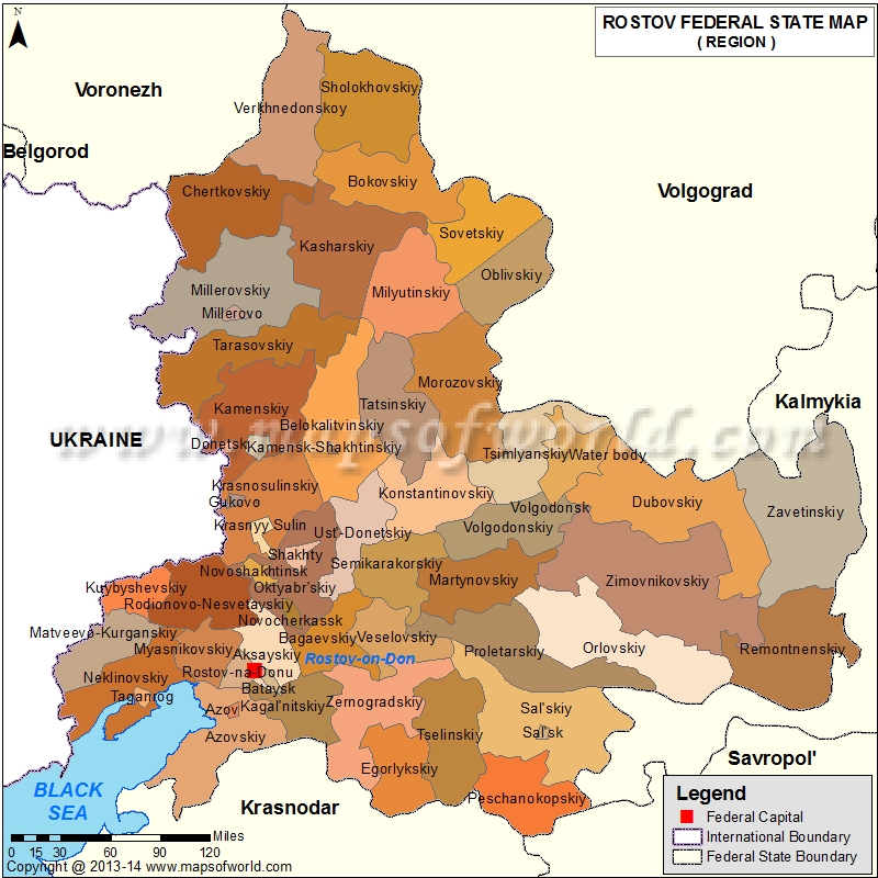
Administratively, Rostov Oblast is divided into 43 raions (districts) and 12 cities of regional significance. Rostov-on-Don, the administrative center and largest city, sits on the lower Don River and acts as a major transportation hub, connecting the region to other parts of Russia and neighboring countries. Other significant cities appearing on the map include Taganrog, Novocherkassk, Shakhty, and Volgodonsk, each with its own unique economic and industrial profile. Volgodonsk, notably, is associated with the massive Tsimlyansk Reservoir and the Volga-Don Canal.
The map showcases the predominantly flat topography of the region. The eastern part of the oblast transitions into semi-arid steppes, influencing land use and agricultural practices. The Chernozem (black earth) soils, particularly fertile in the central and western areas, are ideal for grain cultivation, sunflowers, and other agricultural crops. These areas are often densely populated and characterized by extensive agricultural fields.
The Volga-Don Canal, a major engineering feat, connects the Don and Volga rivers, providing a crucial waterway for cargo transportation between the Caspian Sea and the Black Sea. Its route, clearly visible on the map, highlights the region’s strategic importance in Russia’s transportation infrastructure. The Tsimlyansk Reservoir, created by damming the Don River for the canal project, forms a large body of water crucial for irrigation, hydroelectric power generation, and fisheries.
Furthermore, the map reveals the railway network, connecting Rostov-on-Don to major cities within Russia and neighboring countries like Ukraine. These railways are critical for transporting goods, including grain, coal, and manufactured products. The road network, while less prominent visually, provides access to smaller towns and rural areas, supporting the region’s diverse economy.
The Sea of Azov coastline, located in the southwest, presents a unique ecosystem and supports fishing and tourism industries. Taganrog Bay, a prominent feature, offers port facilities and recreational opportunities. The map would also depict protected areas and nature reserves scattered across the oblast, highlighting efforts to preserve its diverse flora and fauna. From its fertile plains to its strategic waterways, the map of Rostov Oblast tells a story of a region shaped by geography, human endeavor, and its vital role in Russia’s economic and political landscape.
 800×800 rostov map oblast rostov russia from www.mapsofworld.com
 1500×1548 map rostov region russia stock vector royalty shutterstock from www.shutterstock.com
 829×1000 rostov oblast from www.encyclopediaofukraine.com
 728×425 rostov oblast administrative region russia map rostov oblast ru rostov oblast from www.worldatlas.com
 850×726 political shades map rostov oblast from www.maphill.com
 850×726 shaded relief map rostov oblast from www.maphill.com
 1024×604 maps city maps atlases rostov na donu rostovskaia ovlast from www.karsuveikals.lv
 271×300 rostov don city russia travel guide from russiatrek.org
 474×454 satellite map rostov oblast from www.maphill.com
 850×815 physical map rostov oblast from www.maphill.com
 541×570 map rostov oblast maps russia regions planetologcom from planetolog.com
 850×726 physical map rostov oblast from www.maphill.com
 850×781 silver style simple map rostov oblast from www.maphill.com
 560×647 eglise de la resurrection rostov sur le don wikipedia from fr.wikipedia.org
 400×470 rostov wegenwiki from www.wegenwiki.nl
 1023×761 esquema mapa del oblast de rostov bandera from www.deperu.com
 727×732 map rostovskoi oblasti map rostovskoi oblasti rostov oblast maps rostov oblast from maps.newsruss.ru
 610×600 rostov don map russia from www.worldmap1.com
 1300×1390 rostov don map stock vector images alamy from www.alamy.com
 1157×1119 collection pictures grafskiyparkrostovondonrussia latest from finwise.edu.vn
 560×392 large rostov na donu maps print high resolution detailed maps from www.orangesmile.com
 1300×956 rostov na donu fotografias imagenes de alta resolucion alamy from www.alamy.es
 1600×1139 map city rostov don russia stock illustration illustration oblast from www.dreamstime.com
 2550×1421 rostov don map rostov don satellite images from www.istanbul-city-guide.com
 850×500 political location map rostov na donu from www.maphill.com
 2000×920 rostov don russia map facts britannica from www.britannica.com