Sakhalin Oblast, the only island-based region of Russia, stretches along the Russian Far East, encompassing Sakhalin Island and the Kuril Islands archipelago. A map of this region reveals a complex interplay of geography, history, and strategic importance.
Sakhalin Island dominates the map, a long, narrow landmass oriented north-south. Its geography is characterized by two parallel mountain ranges: the East Sakhalin Mountains and the West Sakhalin Mountains. These ranges create a varied landscape of dense forests, rushing rivers, and rolling hills. The Tym-Poronaiskaya lowland separates these mountain ranges, offering some relatively flat terrain and supporting much of the island’s agriculture.
Major cities like Yuzhno-Sakhalinsk, the administrative center, are prominently marked on the map. They are generally located in the southern part of the island, reflecting historical settlement patterns and economic activity. The island’s coastline is indented with numerous bays and inlets, crucial for fishing and port access. Ports like Kholmsk, on the western coast, serve as important transportation hubs connecting the island to the mainland.
The Kuril Islands, arching southwest from Sakhalin Island towards Japan, are a chain of volcanic islands that drastically alter the map’s scope and geopolitical significance. These islands, disputed by Japan, add a layer of complexity to the region. The map clearly distinguishes between the Northern, Central, and Southern Kuril Islands. Key islands like Iturup, Kunashir, Shikotan, and Habomai are visible, even on a scaled-down map, highlighting their individual shapes and positions within the chain.
The physical map also emphasizes the volcanic nature of the Kuril Islands. Marked volcanoes, both active and dormant, are abundant. The rugged terrain of these islands, coupled with frequent seismic activity, presents significant challenges to infrastructure development. The straits between the islands, such as the Strait of Vries, are also essential features, impacting maritime navigation and ecological connectivity.
Resource distribution is another critical aspect reflected in Sakhalin Oblast’s map. Oil and gas deposits are significant, particularly off the northeast coast of Sakhalin Island. Pipeline routes and oil and gas platforms are often marked on specialized maps, indicating the importance of these resources to the regional and national economy. Fishing grounds are also a major economic driver, particularly around the Kuril Islands. The map would highlight areas rich in marine life.
In conclusion, a map of Sakhalin Oblast is more than just a geographical representation. It is a window into the region’s history, its strategic importance, its complex relationship with neighboring countries, and its dependence on natural resources. Understanding the map allows one to appreciate the unique challenges and opportunities that define this remote and fascinating corner of Russia.
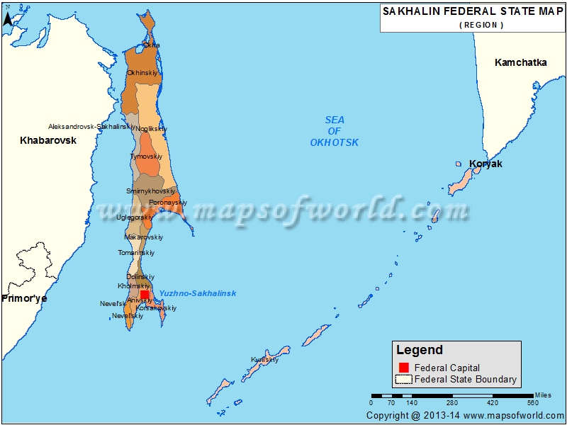 800×600 sakhalin map sakhalin oblast map from www.mapsofworld.com
  482×570 map sakhalin oblast maps russia regions planetologcom from planetolog.com
  780×450 sakhalin oblast from www.russianlessons.net
  850×812 sakhalin map from fity.club
  1091×630 filemap sakhalin oblastsvg countries wiki fandom powered wikia from countries.wikia.com
  600×888 sakhalin wikitravel from wikitravel.org
  850×841 physical map sakhalin oblast from www.maphill.com
  515×600 sakhalin oblast upper territorial units from www.armedconflicts.com
  981×793 sakhalin oblast map from www.amazzzingcards.com
  350×389 sakhalin oblast russia guide from russiatrek.org
  403×434 political simple map sakhalin oblast from www.maphill.com
  1000×1080 map oblast sakhalin royalty vector image vectorstock from www.vectorstock.com
  789×979 aftermath timeline map sakhalin map alternate hist vrogueco from www.vrogue.co
  517×482 sakhalin wikipedia from en.wikipedia.org
  1300×1390 high quality map sakhalin oblast region russia borders districts stock from www.alamy.com
  1200×660 mapofrussia sakhalinoblast defence pointgr from www.defence-point.gr
  713×787 sakhalin island map from ar.inspiredpencil.com
  1300×1126 outline map sakhalin oblast flag regions russia vector illustration stock photo alamy from www.alamy.com
 .svg/1200px-Map_of_Russia_-_Sakhalin_Oblast_(2008-03).svg.png) 1200×692 mlfmap russia sakhalin oblast svg almaarf from www.marefa.org
1200×692 mlfmap russia sakhalin oblast svg almaarf from www.marefa.org  850×841 satellite map sakhalin oblast from www.maphill.com
  499×599 mlfoutline map sakhalin oblastsvg almaarf from www.marefa.org
  1300×1390 kuril islands gray political map volcanic archipelago part sakhalin oblast russian from www.alamy.com
  132×498 fileoutline map sakhalinpng wikimedia commons from commons.wikimedia.org
  400×302 blank location map sakhalin oblast highlighted parent region from www.maphill.com
  178×110 physical location map sakhalin oblast from www.maphill.com
  980×980 sakhalin oblast map administrative division russia illustration vector art from www.vecteezy.com
  1300×1390 kuril islands political map volcanic archipelago part sakhalin oblast russian from www.alamy.com
 .svg/100px-Location_of_Tomarinsky_District_(Sakhalin_Oblast).svg.png) 100×120 categorylocator maps districts sakhalin oblast wikimedia commons from commons.wikimedia.org
100×120 categorylocator maps districts sakhalin oblast wikimedia commons from commons.wikimedia.org  850×812 silver style simple map sakhalin oblast from www.maphill.com
  100×120 dateirelief map sakhalin oblastsvg wikipedia from de.wikipedia.org