
Map of Sovetskaya Gavan Sovetskaya Gavan, located in the Khabarovsk Krai of Russia, is a port city nestled on the shores of the Tatar Strait. A map of Sovetskaya Gavan provides a visual representation of its layout, highlighting key features and facilitating navigation. Understanding the city’s geography is crucial for both residents and visitors. The city’s core is built around its harbor, the main driver of its economy and identity. The map clearly indicates the presence of numerous docks, shipyards, and related industrial facilities lining the waterfront. These represent the backbone of Sovetskaya Gavan’s maritime activities, including fishing, shipbuilding, and cargo transport. Beyond the port area, the map illustrates the city’s residential districts. These are typically characterized by a mix of Soviet-era apartment buildings and more recent constructions. The layout is generally grid-like in older sections, reflecting the urban planning principles prevalent during the Soviet era. Newer developments tend to be more organically arranged. Important landmarks are also marked. These include the city administration building, schools, hospitals, and cultural centers such as museums and theaters. Religious buildings, like Orthodox churches, are usually depicted, providing insight into the city’s spiritual landscape. Parks and recreational areas, such as the city park overlooking the harbor, are also prominent features, offering green spaces for residents. Major transportation routes are vital elements of the map. The railway line connecting Sovetskaya Gavan to the Baikal-Amur Mainline (BAM) is a key artery, facilitating the movement of goods and people. Road networks, including the main highways leading in and out of the city, are clearly indicated, allowing for efficient travel within and beyond Sovetskaya Gavan. Bus routes and stops might also be shown on detailed maps, providing information about public transportation options. Topography plays a significant role in the layout of Sovetskaya Gavan, which is reflected in the map. The city is situated in a hilly area, with the coastline curving around the harbor. Contour lines or shading are often used to depict the elevation changes, revealing how the terrain influences the placement of buildings and infrastructure. Rivers and streams flowing into the harbor are also important geographical features shown on the map. The map may also include information about nearby settlements and points of interest. Villages and towns within the Sovetskaya Gavansky District are often depicted, along with distances and directions. Natural landmarks, such as capes, bays, and islands in the Tatar Strait, are also displayed, providing context for the city’s coastal location. In conclusion, a map of Sovetskaya Gavan is a valuable tool for understanding the city’s infrastructure, layout, and geographical context. From the bustling port to the residential neighborhoods and surrounding natural environment, the map reveals the diverse elements that define this important port city in the Russian Far East.
 336×240 sovetskaya gavan russia map nonanet from nona.net
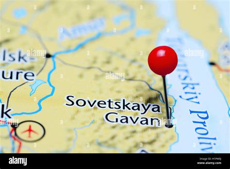
 1300×957 sovetskaya gavan pinned map russia stock photo alamy from www.alamy.com
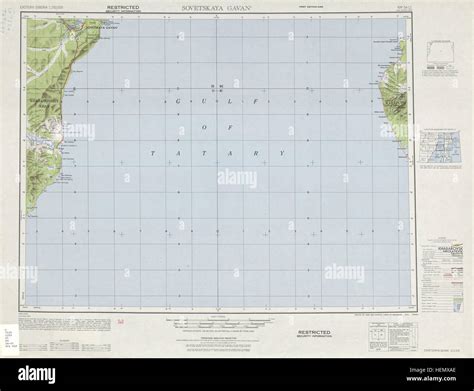
 1300×957 soviet russia map res stock photography images alamy from www.alamy.com
 600×371 sovetskaya gavan location guide from www.weather-forecast.com
 350×200 time sovetskaya gavan current local time dst summerwinter time conversion from 24timezones.com
 1300×1074 sovetskaya gavan res stock photography images alamy from www.alamy.com
 288×449 cartine ferrovia bam bajkalo amurskaya magistral from www.solosiberia.it
 550×382 mappa michelin sovetskaya gavan pinatina sovetskaya gavan viamichelin from www.viamichelin.it
 400×400 sovetskaya gavan water temperature russia from www.seatemperature.org
 600×371 prevision del tiempo sovetskaya gavan from es.weather-forecast.com
850×621 ecological functions vanino sovetskaya gavan districts scientific diagram from www.researchgate.net
 760×485 flotte du pacifique vladivostok petropavlovsk kamtchatski vilyuchinsk kamchatka from www.pinterest.fr
 1280×720 special economic port zone sovetskaya gavan youtube from www.youtube.com
 1024×522 strong mag earthquake tatar strait km southeast sovetskaya gavan khabarovsk from www.volcanodiscovery.com
 700×495 sovetskaya gavan from wikimapia.org
 500×500 sovetskaya gavan vanino khabarovsk krai russia maps simtropolis from community.simtropolis.com
 910×490 sovetskaya gavan russian federation from maritimeoptima.com
 1024×604 direct stop flights sovetskaya gavan khabarovsk schedules flightsfromcom from www.flightsfrom.com
 1024×624 direct stop flights vladivostok sovetskaya gavan schedules flightsfromcom from www.flightsfrom.com
 2053×6389 adgeo evolution seaports russian east relation energy from adgeo.copernicus.org
 320×300 current local time sovetskaya gavan russia from www.generalblue.com
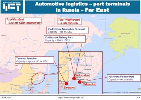 638×452 development russian sea port infrastructure from www.slideshare.net
 1366×768 sunrise sunset times sovetskaya gavan from www.timeanddate.com
 1280×720 sovetskaya gavan sovetskaia gavan puerto del emperador rusia soviet life nature from www.youtube.com
 500×333 port sovetskaya gavan russia vesseltrackercom from www.vesseltracker.com
 600×371 sovetskaya russia tide station location guide from www.tide-forecast.com
 1300×1182 sovetskaya gavan satellite view stock photo alamy from www.alamy.com
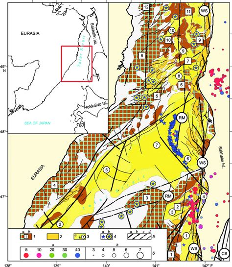 850×979 schematic structure tectonic map south tatar sedimentary basin scientific from www.researchgate.net
 336×240 sovetskaya gavan russia map nonanet from nona.net
  1300×957 sovetskaya gavan pinned map russia stock photo alamy from www.alamy.com
  1300×957 soviet russia map res stock photography images alamy from www.alamy.com
  600×371 sovetskaya gavan location guide from www.weather-forecast.com
  350×200 time sovetskaya gavan current local time dst summerwinter time conversion from 24timezones.com
  1300×1074 sovetskaya gavan res stock photography images alamy from www.alamy.com
  288×449 cartine ferrovia bam bajkalo amurskaya magistral from www.solosiberia.it
  400×400 sovetskaya gavan water temperature russia from www.seatemperature.org
  600×371 prevision del tiempo sovetskaya gavan from es.weather-forecast.com
  850×621 ecological functions vanino sovetskaya gavan districts scientific diagram from www.researchgate.net
  760×485 flotte du pacifique vladivostok petropavlovsk kamtchatski vilyuchinsk kamchatka from www.pinterest.fr
  1280×720 special economic port zone sovetskaya gavan youtube from www.youtube.com
  1024×522 strong mag earthquake tatar strait km southeast sovetskaya gavan khabarovsk from www.volcanodiscovery.com
  700×495 sovetskaya gavan from wikimapia.org
  500×500 sovetskaya gavan vanino khabarovsk krai russia maps simtropolis from community.simtropolis.com
  910×490 sovetskaya gavan russian federation from maritimeoptima.com
  1024×604 direct stop flights sovetskaya gavan khabarovsk schedules flightsfromcom from www.flightsfrom.com
  1024×624 direct stop flights vladivostok sovetskaya gavan schedules flightsfromcom from www.flightsfrom.com
  2053×6389 adgeo evolution seaports russian east relation energy from adgeo.copernicus.org
  320×300 current local time sovetskaya gavan russia from www.generalblue.com
  638×452 development russian sea port infrastructure from www.slideshare.net
  1280×720 sovetskaya gavan sovetskaia gavan puerto del emperador rusia soviet life nature from www.youtube.com
  500×333 port sovetskaya gavan russia vesseltrackercom from www.vesseltracker.com
  600×371 sovetskaya russia tide station location guide from www.tide-forecast.com
  1300×1182 sovetskaya gavan satellite view stock photo alamy from www.alamy.com
  850×979 schematic structure tectonic map south tatar sedimentary basin scientific from www.researchgate.net